|
|
 Graves, Burial Plots and Deceased
Digital Cemetery can manage every kind of cemetery, with a
simple or complex structure, with only sectors and blocks or
levels, rows, special sectors or buildings.
|

|

|
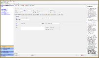
The Data Sheet of a burial plot has different attributes that can be
completely configured by the customer, to match in a perfect way
the configuration of the cemetery.
At the startup you need to specify the attributes of the cemetery,
at least the Sectors (for example Sector A, Sector B, Veterans, etc),
then you can optionally add other kind of attributes and tags (Blocks,
Rows, Levels), in this way you can later identify in a easy way the
burial plot, even in a Mausoleum, Colombarium or Ossuary.
Optionally you can specify the geographic coordinates of every plot,
in this way with just a click you can see the objects on Google Maps
and in a dedicated layer on the map.
|
You can add photos or pictures to the burial sheet.
There is no limit to the number of different cemeteries you can manage,
each one with its structure, configuration and size.
The management of the deceased starts with the burial plot information,
to record the status of the space (reserved or busy), personal data and
includes many customizable information, like the status of the body, the
interment procedure and coroner data.
You can add photos or pictures to the sheet of the deceased.
|
|
|
|
Burial Attributes
Burial attributes managed:
Sectors
Blocks
Rows
Levels
Lots
Spaces
Numbers
Tags
Geographic coordinates
Web site address (for external links on other sites,
for example find a grave)
|
|
)