|
|
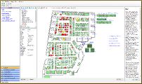
 Map
Map
Each object managed by the software can be visualized in the map,
that you can browse with the available functions like the zoom or panning.
The map is built on layers that be can enabled or disabled using the
tree structure, and calculated in real time: for example free / reserved /
sold burial plots, votive lamps, age of the grave site.
By clicking on the burial plot on the map you have the summary of all the
info about the attributes, the deceased and owner data sheet.
Also the connection between the deceased and its burial plot is done
in an easy way using the browsing of the map.
The map is imported starting from a DXF file created with Autocad or other
CAD software capable of exporting the drawing in this format, for example
the freeware DraftSight,
then you set all the attributes (for example sectors, levels) to the burial plots
using the Map Fast Editing function.
Next updates to the map (for example adding a new Sector or plots) can
be done directly in the software, using the Map Editing
functions.
The map can be created and directly imported by yourself or supplied
in the database as an optional service, to quote separately.
GIS Mapping
Each burial plot managed by the software can be linked to its geographical
position (latitude and longitude), in this way you can obtain a complete
Geographic Information System (GIS) Mapping.
The GIS Mapping is an great tool to provide information for your cemetery
operations and tasks. Since it gives coordinates for specific locations,
you can accurately display your burial plots in the cemetery with linked
data and attributes. With a single click you can see your selected object
in Google Maps.
|
|
|
|
Open Standard
The map functions are based on the Open Standard OpenGIS
(not proprietary standard), available
in the SQLite or PostgreSQL database engine as estensions
(Spatialite or PostGIS).
The database engines are completely free, also for managing
a large quantity of data (maps with thousands of objects)

|
|
)